
 Guess what, 5 years later I am on another generation of backcountry tech devices. Back then, I was carrying a Spot Connect satellite communicator, a Samsung Galaxy III smart phone and a Garmin Oregon 400 handheld GPS. I still carry the same 3 functions, but now it’s a new Garmin InReach Mini, a Galaxy 7, and an Oregon 600. And, no surprise, they are better. The GPS and smartphone were replaced as they died or aged. The new Garmin satellite communicator just out performed the competition.
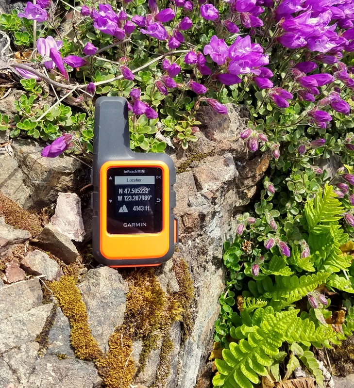
Garmin InReach Mini
The InReach Mini gives me two way SMS communication, which is the new standard for backcountry satellite devices. Emergency notification with location (“calling in the cavalry”) was the first popular backcountry satellite application and still remains an important, if hopefully infrequently used, function. Now having been on the receiving end of one of these contacts, I can say that it is useful, but still leaves lots of room for confusion. Being able to confirm and detail the nature of the emergency and have two way communication with responders makes life better and safer for all concerned. Expanding that two way capability to ordinary messaging offers a new level of utility. Both current SPOT and Garmin InReach devices do this. For higher annual subscription costs, you can also add connection to social media and location tracking. But I am quite happy with a basic level plan. Compared to the SPOT X communicator, the InReach Mini is a hands down winner and when my annual SPOT contract was up, I switched.
With some time in the field, I can report that the Mini works well, with a significant improvement in the speed and reliability of message transmission. Often the SPOT would indicate a message successfully sent, but I wouldn’t get anything at the other end. This was disconcerting for a device that is supposed my backup SOS. Most of this improvement with the Mini seems to be due to Garmin’s use of the better Iridium satellite system.
The Mini gives me an unlimited number of transmissions of 3 preset messages, sent to a predefined list of contacts. I can edit these anytime I am in data range of the Garmin website. In addition I have a large number of quick text messages that I can send to contacts selected from a list saved on the Mini or from any contact on my Bluetooth connected smartphone or phone number or email entered on the Mini. Alphanumeric entries on the Mini are tedious, but workable. But with them the Mini is fully functional even if my smartphone is not working. Still pairing with the phone helps, especially for custom messages, which can be up to 160 characters. All told, in addition to routine progress and “I am still alive” messages, quite complex change of plan communications can occur. Recipients can return text messages to complete the two way link. My basic subscription includes 10 quick text or custom messages per month with extra’s at $.50 each.
 Smartphone
Usually in the backcountry and often even at trailhead, you are out of cell range. There are still enough reasons for me to carry my smartphone with me. GPS location still works. My Garmin InReach subscription gives me access to the Earthmate app, which has background maps available. You need to remember to download these first to have backup GPS navigation. My smartphone is also now my camera. I have an app for wild flower identification. And my smartphone links to my Mini for messaging. Smartphone upgrades happen for ordinary frontcountry reasons, but my refurbished Galaxy 7, in an Otterbox Defender case is a solid performer in the backcountry. I use it lightly to conserve battery.
GPS
 I really have not warmed to GPS applications available on smartphones. If I plan ahead, I can use Earthmate if I am out of cell range without my GPS along. But smartphone battery life with location on and a lot of screen time is too limited. My Garmin 600 gives me maybe 20 hours on on time on a pair of rechargeable AA’s, more with lithium’s. On an extended trip, I carry extra batteries. I like the third party backgound maps available for Garmin units. In my woods and mountains, the maps from Northwest Topos are great. The upgrade to the 600 gave me a touch screen. I like it. It’s only drawback is cold, rainy weather, when it needs protection to keep from doing strange things. On one climb, it suddenly decided to give me all my prompts in French. We had already made the decision to head down, so no big deal. Smartphones often have the same problem. Newer GPS models seem to add stuff I don’t need like cameras, and the 600 keeps delivering.
